Time: 00:00
Correct answers 0 of 0 – 0%
Q1. What clouds and weather may result from an humid and instable air mass, that is pushed against a chain of mountains by the predominant wind and forced to rise?
A. Embedded CB with thunderstorms and showers of hail and/or rain
B. Thin Altostratus and Cirrostratus clouds with light and steady precipitation
C. Overcast low stratus (high fog) with no precipitation
D. Smooth, unstructured NS cloud with light drizzle or snow (during winter)
Q2. What type of fog emerges if humid and almost saturated air, is forced to rise upslope of hills or shallow mountains by the prevailling wind?
A. Orographic fog
B. Steaming fog
C. Radiation fog
D. Advection fog
Q3. What situation is called "over-development" in a weather report?
A. Vertical development of Cumulus clouds to rain showers
B. Widespreading of Cumulus clouds below an inversion layer
C. Change from blue thermals to cloudy thermals during the afternoon
D. Development of a thermal low to a storm depression
Q4. What is the gas composition of "air"?
A.Oxygen 21 % | Water vapour 78 % | Noble gases / carbon dioxide 1 %
B. Oxygen 78 % | Water vapour 21 % | Nitrogen 1 %
C. Nitrogen 21 % | Oxygen 78 % | Noble gases / carbon dioxide 1 %
D. Oxygen 21 % | Nitrogen 78 % | Noble gases / carbon dioxide 1 %
Q5. Weather phenomena are most common to be found in which atmospheric layer?
A. Stratosphere
B. Tropopause
C. Thermosphere
D. Troposphere
Q6. What is the mass of a "cube of air" with the edges 1 m long, at MSL according ISA?
A. 1,225 kg
B. 0,01225 kg
C. 0,1225 kg
D. 12,25 kg
Q7. At what rate does the temperature change with increasing height according to ISA (ICAO Standard Atmosphere) within the troposphere?
A. Decreases by 2° C / 1000 ft
B. Increases by 2° C / 1000 ft
C. Decreases by 2° C / 100 m
D. Increases by 2° C / 100 m
Q8. What is the mean height of the tropopause according to ISA (ICAO Standard Atmosphere)?
A. 18000 ft
B. 11000 ft
C. 11000 m
D. 36000 m
Q9. The term "tropopause" is defined as...
A. the layer above the troposphere showing an increasing temperature
B. the boundary area between the mesosphere and the stratosphere
C. the boundary area between the troposphere and the stratosphere
D. the height above which the temperature starts to decrease
Q10. Temperatures will be given by meteorological aviation services in Europe in which unit?
A. Degrees Centigrade (° C)
B. Kelvin
C. Gpdam
D. Degrees Fahrenheit
Q11. What is meant by "inversion layer"?
A. An atmospheric layer where temperature decreases with increasing height
B. A boundary area between two other layers within the atmosphere
C. An atmospheric layer with constant temperature with increasing height
D. An atmospheric layer where temperature increases with increasing height
Q12. What is meant by "isothermal layer"?
A. An atmospheric layer where temperature increases with increasing height
B. An atmospheric layer where temperature decreases with increasing height
C. A boundary area between two other layers within the atmosphere
D. An atmospheric layer with constant temperature with increasing height
Q13. The temperature lapse rate with increasing height within the troposphere according ISA is...
A. 0,65° C / 100 m
B. 3° C / 100 m
C. 1° C / 100 m
D. 0,6° C / 100 m
Q14. Which process may result in an inversion layer at about 5000 ft (1500 m) height?
A. Intensive sunlight insolation during a warm summer day
B. Widespread descending air within a high pressure area
C. Ground cooling by radiation during the night
D. Advection of cool air in the upper troposphere
Q15. An inversion layer close to the ground can be caused by...
A. ground cooling during the night
B. large-scale lifting of air
C. intensifying and gusting winds
D. thickening of clouds in medium layers
Q16. What is the ISA standard pressure at FL 180 (5500 m)?
A. 250 hPa
B. 300 hPa
C. 1013.25 hPa
D. 500 hPa
Q17. The pressure which is measured at a ground station and reduced to mean sea level (MSL) by means of the actual atmospheric conditions is called...
A. QNH
B. QNE
C. QFE
D. QFF
Q18. Which processes result in decreasing air density?
A. Decreasing temperature, increasing pressure
B. Increasing temperature, decreasing pressure
C. Increasing temperature, increasing pressure
D. Decreasing temperature, decreasing pressure
Q19. The pressure at MSL in ISA conditions is...
A. 113.25 hPa
B. 15 hPa
C. 1013.25 hPa
D. 1123 hPa
Q20. The height of the tropopause of the International Standard Atmosphere (ISA) is at...
A. 5500 ft
B. 11000 ft
C. 36000 ft
D. 48000 ft
Q21. The barometric altimeter indicates height above...
A. a selected reference pressure level
B. mean sea level
C. standard pressure 1013.25 hPa
D. ground
Q22. The altimeter can be checked on the ground by setting...
A. QFE and comparing the indication with the airfield elevation
B. QNH and comparing the indication with the airfield elevation
C. QNE and checking that the indication shows zero on the ground
D. QFF and comparing the indication with the airfield elevation
Q23. The barometric altimeter with QFE setting indicates...
A. height above the pressure level at airfield elevation
B. true altitude above MSL
C. height above MSL
D. height above standard pressure 1013.25 hPa
Q24. The barometric altimeter with QNH setting indicates...
A. height above standard pressure 1013.25 hPa
B. height above the pressure level at airfield elevation
C. true altitude above MSL
D. height above MSL
Q25. Given the following information, what is the true altitude? (rounded to the nearest 50 ft)
QNH: 983 hPa
Altitude: FL 85
Outside Air Temperature: ISA - 10°
A. 7900 ft
B. 9400 ft
C. 7300 ft
D. 7600 ft
Q26. How can wind speed and wind direction be derived from surface weather charts?
A. By alignment and distance of isobaric lines
B. By alignment and distance of hypsometric lines
C. By alignment of lines of warm- and cold fronts
D. By annotations from the text part of the chart
Q27. Which force causes "wind"?
A. Centrifugal force
B. Thermal force
C. Coriolis force
D. Pressure gradient force
Q28. Above the friction layer, with a prevailing pressure gradient, the wind direction is...
A. perpendicular to the isohypses
B. at an angle of 30° to the isobars towards low pressure
C. parallel to the isobars
D. perpendicular to the isobars
Q29. Which of the stated surfaces will reduce the wind speed most due to ground friction?
A. Flat land, deserted land, no vegetation
B. Oceanic areas
C. Mountainous areas, vegetation cover
D. Flat land, lots of vegetation cover
Q30. The movement of air flowing together is called...
A. convergence
B. divergence
C. soncordence
D. subsidence
Q31. The movement of air flowing apart is called...
A. convergence
B. concordence
C. divergence
D. subsidence
Q32. What weather development will result from convergence at ground level?
A. Descending air and cloud formation
B. Ascending air and cloud dissipation
C. Descending air and cloud dissipation
D. Ascending air and cloud formation
Q33. When air masses meet each other head on, how is this referred to and what air movements will follow?
A. Convergence resulting in sinking air
B. Divergence resulting in sinking air
C. Convergence resulting in air being lifted
D. Divergence resulting in air being lifted
Q34. What are the air masses that Central Europe is mainly influenced by?
A. Arctic and polar cold air
B. Polar cold air and tropical warm air
C. Equatorial and tropical warm air
D. Tropical and arctic cold air
Q35. With regard to global circulation within the atmosphere, where does polar cold air meets subtropical warm air?
A. At the equator
B. At the geographic poles
C. At the subtropical high pressure belt
D. At the polar front
Q36. Winds blowing uphill are defined as...
A. katabatic winds
B. anabatic winds
C. convergent winds
D. subsident winds
Q37. Winds blowing downhill are defined as...
A. anabatic winds
B. katabatic winds
C. convergent winds
D. subsident winds
Q38. Air descending behind a mountain range is defined as...
A. katabatic wind
B. convergent wind
C. anabatic wind
D. divergent wind
Q39. "Foehn" conditions usually develop with...
A. instability, widespread air blown against a mountain ridge
B. stability, widespread air blown against a mountain ridge
C. instability, high pressure area with calm wind
D. stability, high pressure area with calm wind
Q40. What type of turbulence is typically found close to the ground on the lee side during Foehn conditions?
A. Inversion turbulence
B. Turbulence in rotors
C. Clear-air turbulence (CAT)
D. Thermal turbulence
Q41. Light turbulence always has to be expected...
A. above cumulus clouds due to thermal convection
B. below stratiform clouds in medium layers
C. when entering inversions
D. below cumulus clouds due to thermal convection
Q42. Moderate to severe turbulence has to be expected...
A. with the appearance of extended low stratus clouds (high fog)
B. overhead unbroken cloud layers
C. below thick cloud layers on the windward side of a mountain range
D. on the lee side of a mountain range when rotor clouds are present
Q43. Which answer contains every state of water found in the atmosphere?
A. Liquid and solid
B. Liquid, solid, and gaseous
C. Gaseous and liquid
D. Liquid
Q44. How do dew point and relative humidity change with decreasing temperature?
A. Dew point remains constant, relative humidity decreases
B. Dew point decreases, relative humidity increases
C. Dew point increases, relative humidity decreases
D. Dew point remains constant, relative humidity increases
Q45. How do spread and relative humidity change with increasing temperature?
A. Spread increases, relative humidity decreases
B. Spread remains constant, relative humidity decreases
C. Spread increases, relative humidity increases
D. Spread remains constant, relative humidity increases
Q46. The "spread" is defined as...
A. relation of actual to maximum possible humidity of air
B. maximum amount of water vapour that can be contained in air
C. difference between dew point and condensation point
D. difference between actual temperature and dew point
Q47. With other factors remaining constant, decreasing temperature results in...
A. decreasing spread and decreasing relative humidity
B. increasing spread and decreasing relative humidity
C. increasing spread and increasing relative humidity
D. decreasing spread and increasing relative humidity
Q48. What process causes latent heat being released into the upper troposphere?
A. Descending air across widespread areas
B. Stabilisation of inflowing air masses
C. Cloud forming due to condensation
D. Evaporation over widespread water areas
Q49. The saturated adiabatic lapse rate is...
A. lower than the dry adiabatic lapse rate
B. proportional to the dry adiabatic lapse rate
C. higher than the dry adiabatic lapse rate
D. equal to the dry adiabatic lapse rate
Q50. The dry adiabatic lapse rate has a value of...
A. 1,0° C / 100 m
B. 2° / 1000 ft
C. 0,6° C / 100 m
D. 0,65° C / 100 m
Q51. The saturated adiabatic lapse rate should be assumed with a mean value of:
A. 1,0° C / 100 m
B. 0° C / 100 m
C. 0,6° C / 100 m
D. 2° C / 1000 ft
Q52. What weather conditions may be expected during conditionally unstable conditions?
A. Layered clouds up to high levels, prolonged rain or snow
B. Shallow cumulus clouds with base at medium levels
C. Sky clear of clouds, sunshine, low winds
D. Towering cumulus, isolated showers of rain or thunderstorms
Q53. Which conditions are likely for the formation of advection fog?
A. Cold, humid air moves over a warm ocean
B. Warm, humid air moves over a cold surface
C. Warm, humid air cools during a cloudy night
D. Humidity evaporates from warm, humid ground into cold air
Q54. Clouds are basically distinguished by what types?
A. Stratiform and ice clouds
B. Layered and lifted clouds
C. Cumulus and stratiform clouds
D. Thunderstorm and shower clouds
Q55. Clouds in high layers are referred to as...
A. Nimbo-
B. Strato-
C. Alto-
D. Cirro-
Q56. What weather phenomenon designated by "2" has to be expected on the lee side during "Foehn" conditions? .
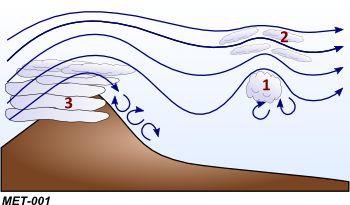
A. Altocumulus Castellanus
B. Nimbostratus
C. Cumulonimbus
D. Altocumulus lenticularis
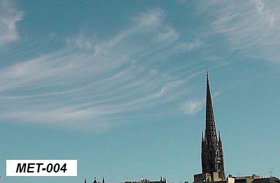
Q57. What cloud type does the picture show? .
A. Stratus
B. Cumulus
C. Altus
D. Cirrus
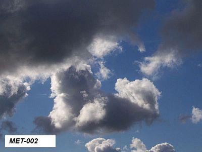
Q58. What cloud type does the picture show? .
A. Altocumulus
B. Cumulus
C. Stratus
D. Cirrus
Q59. What factor may affect the top of cumulus clouds?
A. Relative humidity
B. The spread
C. The presence of an inversion layer
D. The absolute humidity
Q60. What factors may indicate a tendency to fog formation?
A. Low pressure, increasing temperature
B. Low spread, decreasing temperature
C. Low spread, increasing temperature
D. Strong winds, decreasing temperature
Q61. What condition may prevent the formation of "radiation fog"?
A. Overcast cloud cover
B. Calm wind
C. Low spread
D. Clear night, no clouds
Q62. What process results in the formation of "advection fog"?
A. Cold, moist air is being moved across warm ground areas
B. Warm, moist air is moved across cold ground areas
C. Cold, moist air mixes with warm, moist air
D. Prolonged radiation during nights clear of clouds
Q63. What process results in the formation of "orographic fog" ("hill fog")?
A. Prolonged radiation during nights clear of clouds
B. Warm, moist air is moved across a hill or a mountain range
C. Cold, moist air mixes with warm, moist air
D. Evaporation from warm, moist ground area into very cold air
Q64. What factors are required for the formation of precipitation in clouds?
A. High humidity and high temperatures
B. The presence of an inversion layer
C. Calm winds and intensive sunlight insolation
D. Moderate to strong updrafts
Q65. The formation of medium to large precipitation particles requires...
A. a high cloud base
B. strong wind
C. an inversion layer
D. strong updrafts
Q66. Which type of cloud is associated with prolonged rain?
A. Cumulonimbus
B. Cirrostratus
C. Nimbostratus
D. Altocumulus
Q67. Regarding the type of cloud, precipitation is classified as...
A. light and heavy precipitation
B. showers of snow and rain
C. prolonged rain and continuous rain
D. rain and showers of rain
Q68. How is an air mass described when moving to Central Europe via the Russian continent during winter?
A. Maritime tropical air
B. Continental tropical air
C. Continental polar air
D. Maritime polar air
Q69. The character of an air mass is given by what properties?
A. Temperatures at origin and present region
B. Wind speed and tropopause height
C. Region of origin and track during movement
D. Environmental lapse rate at origin
Q70. The symbol labeled (1) as shown in the picture is a / an...
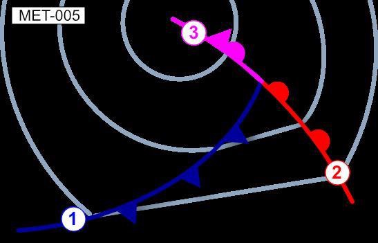
A. front aloft
B. occlusion
C. warm front
D. cold front
Q71. The symbol labeled (2) as shown in the picture is a / an...
A. front aloft
B. cold front
C. warm front
D. occlusion
Q72. The symbol labeled (3) as shown in the picture is a / an...
A. front aloft
B. warm front
C. cold front
D. occlusion
Q73. What cloud sequence can typically be observed during the passage of a warm front?
A. In coastal areas during daytime wind from the coast and forming of cumulus clouds, dissipation of clouds during evening and night
B. Wind becoming calm, dissipation of clouds and warming during summer; formation of extended high fog layers during winter
C. Squall line with showers of rain and thunderstorms (Cb), gusting wind followed by cumulus clouds with isolated showers of rain
D. Cirrus, thickening altostratus and altocumulus clouds, lowering cloud base with rain, nimbostratus
Q74. What clouds and weather can typically be observed during the passage of a cold front?
A. In coastal areas during daytime wind from the coast and forming of cumulus clouds, dissipation of clouds during evening and night
B. Strongly developed cumulus clouds (Cb) with showers of rain and thunderstorms, gusting wind followed by cumulus clouds with isolated showers of rain
C. Cirrus, thickening altostratus and altocumulus clouds, lowering cloud base with rain, nimbostratus
D. Wind becoming calm, dissipation of clouds and warming during summer; formation of extended high fog layers during winter
Q75. What visual flight conditions can be expected within the warm sector of a polar front low during summer time?
A. Visibilty less than 1000 m, cloud-covered ground
B. Good visibility, some isolated high clouds
C. Moderate to good visibility, scattered clouds
D. Moderate visibility, heavy showers and thunderstorms
Q76. What visual flight conditions can be expected after the passage of a cold front?
A. Scattered cloud layers, visbility more than 5 km, formation of shallow cumulus clouds
B. Good visiblity, formation of cumulus clouds with showers of rain or snow
C. Medium visibility with lowering cloud bases, onset of prolonged precipitation
D. Poor visibility, formation of overcast or ground-covering stratus clouds, snow
Q77. A boundary between a cold polar air mass and a warm subtropical air mass showing no horizontal displacement is called...
A. cold front
B. warm front
C. occluded front
D. stationary front
Q78. What is the usual direction of movement of a polar front low?
A. To the northwest during winter, to the southwest during summer
B. To the northeast during winter, to the southeast during summer
C. Parallel to the warm front line to the south
D. Parallel to the the warm-sector isobars
Q79. What pressure pattern can be observed during the passage of a polar front low?
A. Rising pressure in front of the warm front, constant pressure within the warm sector, rising pressure behind the cold front
B. Falling pressure in front of the warm front, constant pressure within the warm sector, rising pressure behind the cold front
C. Falling pressure in front of the warm front, constant pressure within the warm sector, falling pressure behind the cold front
D. Rising pressure in front of the warm front, rising pressure within the warm sector, falling pressure behind the cold front
Q80. What pressure pattern can be observed when a cold front is passing?
A. Continually decreasing pressure
B. Shortly decreasing, thereafter increasing pressure
C. Continually increasing pressure
D. Constant pressure pattern
Q81. What change of wind direction can be expected during the passage of a polar front low in Central Europe?
A. Backing wind during passage of the warm front, veering wind during passage of the cold front
B. Backing wind during passage of the warm front, backing wind during passage of the cold front
C. Veering wind during passage of the warm front, veering wind during passage of the cold front
D. Veering wind during passage of the warm front, backing wind during passage of the cold front
Q82. Extensive high pressure areas can be found throughout the year ...
A. in areeas showing extensive lifting processes
B. in mid latitudes along the polar front
C. over oceanic areas at latitues around 30°N/S
D. in tropical areas, close to the equator
Q83. What cloud type can typically be observed across widespread high pressure areas during summer?
A. Overcast low stratus
B. Scattered Cu clouds
C. Overcast Ns clouds
D. Squall lines and thunderstorms
Q84. What pressure pattern may result from cold-air inflow in high tropospheric layers?
A. Formation of a low in the upper troposphere
B. Formation of a high in the upper troposphere
C. Formation of a large ground low
D. Alternating pressure
Q85. Cold air inflow in high tropospheric layers may result in...
A. showers and thunderstorms
B. stabilisation and calm weather
C. frontal weather
D. calm weather and cloud dissipation
Q86. How does inflowing cold air affect the shape and vertical distance between pressure layers?
A. Increasing vertical distance, raise in height (high pressure)
B. Decreasing vertical distance, raise in height (high pressure)
C. Decrease in vertical distance, lowering in height (low pressure)
D. Increase in vertical distance, lowering in height (low pressure)
Q87. What weather phenomena have to be expected around an upper-level trough?
A. Calm wind, forming of shallow cumulus clouds
B. Calm weather, formation of lifted fog layers
C. Formation of high stratus clouds, ground-covering cloud bases
D. Development of showers and thunderstorms (Cb)
Q88. What frontal line divides subtropical air from polar cold air, in particular across Central Europe?
A. Occlusion
B. Cold front
C. Polar front
D. Warm front
Q89. What weather conditions can be expected in high pressure areas during summer?
A. Changing weather with passing of frontal lines
B. Squall lines and thunderstorms
C. Calm winds and widespread areas with high fog
D. Calm weather and cloud dissipation, few high Cu
Q90. What weather conditions in Central Europe are typically found in high pressure areas during summer?
A. Large isobar spacing with calm winds, formation of local wind systems
B. Large isobar spacing with strong prevailing westerly winds
C. Small isobar spacing with calm winds, formation of local wind systems
D. Small isobar spacing with strong prevailing northerly winds
Q91. What weather conditions can be expected in high pressure areas during winter?
A. Changing weather with passing of frontal lines
B. Calm weather and cloud dissipation, few high Cu
C. Calm winds and widespread areas with high fog
D. Squall lines and thunderstorms
Q92. What wind conditions can be expected in areas showing large distances between isobars?
A. Formation of local wind systems with strong prevailing westerly winds
B. Strong prevailing easterly winds with rapid backing
C. Strong prevailing westerly winds with rapid veering
D. Variable winds, formation of local wind systems
Q93. What weather conditions can be expected during "Foehn" on the windward side of a mountain range?
A. Dissipating clouds with unusual warming, accompanied by strong, gusty winds
B. Scattered cumulus clouds with showers and thunderstorms
C. Layered clouds, mountains obscured, poor visibility, moderate or heavy rain
D. Calm wind and forming of high stratus clouds (high fog)
Q94. Which of the stated wind phenomena will increase in speed since its path is narrowed by mountains?
A. Bora
B. Mistral
C. Scirocco
D. Passat
Q95. What is the name of the the cold, katabatic wind phenomena blowing from northeast into the Adriatic Sea?
A. Scirocco
B. Mistral
C. Bora
D. Passat
Q96. Which of the following conditions are most favourable for ice accretion?
A. Temperatures between 0° C and -12° C, presence of supercooled water droplets (clouds)
B. Temperaturs below 0° C, strong wind, sky clear of clouds
C. Temperatures between +10° C and -30° C, presence of hail (clouds)
D. Temperatures between -20° C and -40° C, presence of ice crystals (Ci clouds)
Q97. What temperatures are most dangerous with respect to airframe icing?
A. +5° to -10° C
B. 0° to -12° C
C. -20° to -40° C
D. +20° to -5° C
Q98. Which type of ice forms by very small water droplets and ice crystals hitting the front surfaces of an aircraft?
A. Clear ice
B. Mixed ice
C. Hoar frost
D. Rime ice
Q99. Which type of ice forms by large, supercooled droplets hitting the front surfaces of an aircraft?
A. Hoar frost
B. Clear ice
C. Rime ice
D. Mixed ice
Q100. What situation may result in the occurrence of severe wind shear?
A. Flying ahead of a warm front with visible Ci clouds
B. Cross-country flying below Cu clouds with about 4 octas coverage
C. During final approach, 30 min after a heavy shower has passed the airfield
D. When a shower is visible close to the airfield
Q101. What conditions are favourable for the formation of thunderstorms?
A. Warm humid air, conditionally unstable environmental lapse rate
B. Calm winds and cold air, overcast cloud cover with St or As
C. Clear night over land, cold air and patches of fog
D. Warm and dry air, strong inversion layer
Q102. What conditions are mandatory for the formation of thermal thunderstorms?
A. Conditionally unstable atmosphere, low temperature and low humidity
B. Absolutely stable atmosphere, high temperature and high humidity
C. Absolutely stable atmosphere, high temperature and low humidity
D. Conditionally unstable atmosphere, high temperature and high humidity
Q103. With regard to thunderstorms, strong up- and downdrafts appear during the...
A. initial stage
B. dissipating stage
C. mature stage
D. thunderstorm stage
Q104. Which stage of a thunderstorm is dominated by updrafts?
A. Dissipating stage
B. Upwind stage
C. Mature stage
D. Cumulus stage
Q105. What danger is most immenent when an aircraft is hit by lightning?
A. Rapid cabin depressurization and smoke in the cabin
B. Surface overheat and damage to exposed aircraft parts
C. Explosion of electrical equipment in the cockpit
D. Disturbed radio communication, static noise signals
Q106. Heavy downdrafts and strong wind shear close to the ground can be expected...
A. during cold, clear nights with the formation of radiation fog
B. near the rainfall areas of heavy showers or thunderstorms
C. during approach to an airfield at the coast with a strong sea breeze
D. during warm summer days with high, flatted Cu clouds
Q107. What phenomenon is caused by cold air downdrafts with precipitation from a fully developed thunderstorm cloud?
A. Electrical discharge
B. Anvil-head top of Cb cloud
C. Gust front
D. Freezing Rain
Q108. What has to be considered when taking off in a ground inversion?
A. Climb should be performed with the lowest possible speed and maximum power
B. Due to low temperatures close to the ground, icing has to be expected
C. During climb, a sudden decrease in speed and climb performance has to be expected
D. During the climb, a sudden increase in speed and climb performance has to be expected
Q109. What danger is most imminent during an approach to an airfield situated in a valley, with strong wind aloft blowing perpendicular to the mountain ridge?
A. Reduced visibilty, maybe loss of sight to the airfield during final approach
B. Formation of medium to heavy clear ice on all aircraft surfaces
C. Heavy downdrafts within rainfall areas below thunderstorm clouds
D. Wind shear during descent, wind direction may change by 180°
Q110. What kind of reduction in visibility is not very sensitive to changes in temperature?
A. Haze (HZ)
B. Patches of fog (BCFG)
C. Radiation fog (FG)
D. Mist (BR)
E. wind chart
F. surface weather chart
G. Significant Weather Chart (SWC)
H. hypsometric chart
Q111. Information about pressure patterns and frontal situation can be found in which chart?
A. wind chart.
B. surface weather chart.
C. Significant Weather Chart (SWC).
D. hypsometric chart.
Q112. Which weather chart shows the actual air pressure as in MSL along with pressure centers and fronts?
A. Hypsometric chart
B. Surface weather chart
C. Prognostic chart
D. Wind chart
Q113. What information can be obtained from satallite images?
A. Temperature and dew point of environmental air
B. Turbulence and icing
C. Flight visibility, ground visibility, and ground contact
D. Overview of cloud covers and front lines
Q114. What chart shows areas of precipitation?
A. GAFOR
B. Wind chart
C. Satellite picture
D. Radar picture
Q115. What information is NOT found on Low-Level Significant Weather Charts (LLSWC)?
A. Information about icing conditions
B. Radar echos of precipitation
C. Information about turbulence areas
D. Front lines and frontal displacements
Q116. Measured pressure distribution in MSL and corresponding frontal systems are displayed by the...
A. prognostic chart.
B. Significant Weather Chart (SWC).
C. surface weather chart.
D. hypsometric chart.
Q117. In a METAR, "heavy rain" is designated by the identifier...
A. RA
B. +SHRA
C. SHRA
D. +RA
Q118. In a METAR, "(moderate) showers of rain" are designated by the identifier...
A. +RA
B. SHRA
C. +TSRA
D. TS
Q119. What information can be found in the ATIS, but not in a METAR?
A. Information about current weather, for example types of precipitation
B. Operational information such as runway in use and transition level
C. Information about mean wind speeds, maximum speeds in gusts if applicable
D. Approach information, such as ground visibility and cloud base
Q120. Weather and operational information about the destination aerodrome can be obtained during the flight by...
A. VOLMET.
B. PIREP.
C. ATIS.
D. SIGMET.
Q121. SIGMET warnings are issued for...
A. specific routings
B. airports
C. FIRs / UIRs
D. countries
Q122. An inversion is a layer ...
A. with increasing pressure with increasing height
B. with decreasing temperature with increasing height
C. with constant temperature with increasing height
D. with increasing temperature with increasing height
Q123. What can be expected for the prevailling wind with isobars on a surface weather chart showing large distances?
A. Strong pressure gradients resulting in strong prevailling wind
B. Strong pressure gradients resulting in low prevailling wind
C. Low pressure gradients resulting in strong prevailling wind
D. Low pressure gradients resulting in low prevailling wind
Q124. What is referred to as mountain wind?
A. Wind blowing uphill from the valley during daytime
B. Wind blowing uphill from the valley during the night
C. Wind blowing down the mountain side during the night
D. Wind blowing down the mountain side during daytime
Q125. Under which conditions "back side weather" ("Rückseitenwetter") can be expected?
A. before passing of an occlusion
B. During Foehn at the lee side
C. After passing of a warm front
D. After passing of a cold front
Q126. What wind is reportet as 225/15 ?
A. north-east wind with 15 kt
B. south-west wind with 15 km/h
C. north-east wind with 15 km/h
D. south-west wind with 15 kt
Q127. How does air temperature change in ISA from MSL to approx. 10.000 m height?
A. from +20° to -40°C
B. from +30° to -40°C
C. from -15° to 50°C
D. from +15° to -50°C
Q128. What weather is likely to be experienced during "Foehn" in the Bavarian area close to the alps?
A. High pressure area overhead Biskaya and low pressure area in Eastern Europe
B. Cold, humid downhill wind on the lee side of the alps, flat pressure pattern
C. Nimbostratus cloud in the northern alps, rotor clouds at the windward side, warm and dry wind
D. Nimbostratus cloud in the southern alps, rotor clouds at the lee side, warm and dry wind
Q129. Mountain side updrafts can be intensified by ...
A. Solar irradiation on the windward side
B. Solar irradiation on the lee side
C. By warming of upper atmospheric layers
D. thermal radiation of the windward side during the night Anlagen zu den Aufgaben v2020.2